- Waiting for Data..
- Airline
- Nil Data
- Aircraft Type
- Nil Data
- Status
- Nil Data
- Latitude
- Nil Data
- Groundspeed
- Nil Data
- Altitude
- Nil Data
- Squawk
- Nil Data
- Callsign
- Nil Data
- ModeS
- Nil Data
- Registration
- Nil Data
- Longitude
- Nil Data
- Track
- Nil Data
- Vertical Rate
- Nil Data
- Distance
- Nil Data
- Origin
- Nil Data
- Via
- Nil Data
- Destination
- Nil Data

Live ATC Audio
This live audio feed is provided by liveatc.net. Thanks go to the owner Dave for allowing me to link to the streams.Note: As these streams are run by a third party, I have no control over their availability.
 (in new browser window, requires Flash) (in new browser window, requires Flash) | |
| (in new browser window, requires Java) | (launches your Windows Media player) | (launches your MP3 player - Use for IOS Devices) |
Frequently Asked Questions
Website Related Questions
Aircraft don't seem to be updating.. why?
A: Are you running Internet Explorer? If so, go into Tools, Internet Options, General, Browsing History, and ensure "Every time I visit the webpage" is ticked.
What's the deal with seeing 'Nil Data' in the Flight Data, and Tooltips?
A: If information about an aircraft isn't available at the time of plotting, the corresponding field will be 'Nil Data'. Example, if an aircraft doesn't transmit a Squawk code then the field will be left as 'Nil Data'. Also in the case where an aircraft is received but no database records exist, then data such as routes, Airline, Aircraft Type, and Registration will be unavailable and therefore display as 'Nil Data'.
How long does it take for an aircraft to time out and disappear from the map?
A: Aircraft information is transmitted in multiple messages. Some messages may contain information such as Callsign and nothing else, and others carry the latitude and longitude. If any messages are received for an aircraft, whether they contain location information or not, they will stay on the map. When no data has been received for about a minute, then the aircraft will disappear from the map a short time afterwards.
What does 'HOME' mean on the Aircraft List?
A: When you click on HOME, it resets the map to the default map location which is centered on Waterford West, QLD. It also stops tracking specific aircraft.
Where is the receiver located?
A: The receiver is located at my home in Waterford West, QLD, Australia.
What is the Distance field based on?
A: The Distance field in the Flight Data section is based on the location of the receiver which is located in Waterford West, QLD.
Sometimes when I click on an aircraft the map changes but the flight information in the tooltip is incorrect. Why?
A: This is a known bug. Normally Google Maps will pan to a new location. If the new location is too distant, the map will just load new tiles. While I'm able to fix this, I've chosen not to for other technical reasons. The problem will fix itself when it next updates the data. This should be within 10 seconds. You can also move your mouse over the aircraft icon to force a new aircraft tooltip.
How often does the Flight Data get updated?
A: Currently this is set to every 10 seconds.
If I see 'Nil Data' (missing information) and I know what the information is, can I email you?
A: By all means. I want to go through the database and update it with more up to date information so if you can supply any, i'd love to hear from you. Just use the 'Contact us' to email me.
Why do aircraft tend to stop and/or disappear often on the map?
A: I live in a house located around 40km from Brisbane Airport. Since the house is low to the ground, the signal coverage can vary greatly depending on trees, and line of site to the aircraft. If the antenna located on the roof looses visible site of the aircraft the signal can be lost.
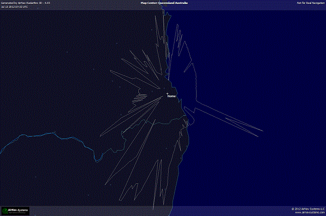
Do you have a polar diagram of your signal coverage?
A: Yes, see below.
What do the up, down, and right arrows mean on the aircraft tooltip?
A: The arrows indicate the vertical rate status. Up arrow means the aircraft is ascending, down arrow means it's descending, and the right arrow means it's level.
What are all the numbers and letters on the aircraft tooltip mean?
A: To the left of the brackets is the aircraft ModeS assignment or callsign (If received from the aircraft). Inside the brackets are the aircraft registration. On the bottom part of the tooltip from left to right is the Track, Groundspeed, Altitude and the arrow indicates whether the aircraft is ascending, descending or flying level. Finally on the last line is the squawk code. This is the 4 digit transponder code transmitted by the aircraft to assist air traffic controllers in traffic separation.
What's your privacy policy?
A: This site serves google ads which in turn may use technology to track the patterns of behaviour of visitors to the site. This can include using a "cookie" which would be stored in your browser. You can modify your browser to prevent this from happening should you chose to do so.
- Google, as a third party vendor, uses cookies to serve ads on this site.
- Google's use of the DART cookie enables it to serve ads to our users based on your visit to our site and other sites on the Internet
Users may opt out of the use of the DART cookie by visiting the Google ad and content network privacy policy.
What happens if an aircraft transmits an emergency squawk code?
A: In the event an aircraft transmits a squawk code of 7500, 7600, or 7700, the code will flash in the Flight Data window (Only if you are tracking that aircraft).
Why don't I see any aircraft. It keeps saying 'No visible aircraft'?
A: Since Brisbane Airport doesn't operate a curfew, it's possible the site may be down. Feel free to email me to alert me to the situation. It's also possible there are no aircraft currently being picked up by my receiver.
Aircraft Related Questions
Sometimes I see an aircraft in virtually the same position as another. Why is that?
A: When an aircraft signal is lost, the aircraft will still appear on the map for approximately 1 minute. The aircraft will also continue to stay on the map if messages are received but none of the messages contain updated Latitude and Longitude information.
Occasionally routes for an aircraft appear to be incorrect. Why?
Aircraft routes are not transmitted by the aircraft, but rather looked up in a database. Sometimes the data in the database can be out of date.
What information is transmitted by the aircraft?
A: Latitude, Longitude, Altitude, Groundspeed, Track, Squawk, Callsign, ModeS, and Vertical Rate.
What information is looked up in a database?
A: Airline, Aircraft Type, Registration, and route information. This information can be out of date. If you know of any information that is out of date, please let me know so I can correct it.
How can you work out the Flight Number of an aircraft?
A: While there is no hard and fast rule for doing so, you can usually make an educated guess by looking at the Callsign (if received by the aircraft). The first few letters of a callsign is an identifier of the airline. The numbers are usually representative of the Flight number. Example, If you see QFA6 as a callsign, the Flight number is Qantas flight 6. A callsign of JST456 would be Jetstar flight 456 etc.
What are the airlines associated with the callsign letters?
A: There are too many to list but the more common ones you’ll see on this site are:
- QFA: Qantas
- JST: Jetstar
- BAW: British Airways
- MAS: Malaysia Airlines
- SIA: Singapore Airlines
- VOZ: Virgin Australia
- UAE: Emirates Airlines
- GIA: Garuda Indonesia
- ANZ: Air New Zealand
- TGW: Tiger Airways
- REU: Air Austral
- VAU: V Australia
- FDX: Federal Express
- PBN: Pacific Blue Airlines
- CPA: Cathay Pacific Airways
- KAL: Korean Air Cargo
- CAL: China Airlines
- THA: Thai Airways International
- UAL: United Airlines
What are the emergency Squawk codes?
Emergency squawk codes are as follows
- 7500 - Unlawful Interference ie. hijacking
- 7600 - Lost Communications
- 7700 - General Emergency (This could vary and may include but not limited to things such as illness on board, or full scale emergency)
Sometimes I see an aircraft located somewhere thousands of kilometres away. Is this even possible?
A: No, the frequency used by ADS-B is 1090Mhz which is line of sight. In the best of circumstances you would expect to pick up an aircraft at most around 400 kilometres away, however, in my case it's closer to 250km away. The Latitude and Longitude is transmitted from the aircraft and is decoded by the receiver. While it doesn't happen often, occasionally aircraft will transmit incorrect information. This is particularly evident when you see an aircraft jumping thousands of kilometres in only a matter of seconds.
A:
A:
My Flight Tracking History
Flight tracking has been a hobby of mine for a few years. I started off being a plane spotter, or rather going to Sydney Airport and watching planes take off and land. I'd spend hours at several vantage points including the Control Tower, and inside the International Terminal to watch aircraft arriving and departing.
While surfing the Internet, I came across a device called an SBS-1 Virtual Radar by Kinetic-Avionics.
The SBS-1 Virtual Radar basically decodes ADS-B (Automatic Dependent Surveillance – Broadcast) signals from aircraft within a range of approximately 250nm (dependent on signal strength). The latest technology used by commercial aircraft is to transmit location data obtained by GPS to air traffic control using radio signals via ground stations. This is far different from normal radar, which works by bouncing radio waves from fixed terrestrial antennas off of aircraft and then interpreting the reflected signals. Aircraft transmit ADS-B signals at 1090Mhz and contain airborne information such as Altitude, Latitude, Longitude, Groundspeed, Vertical Rate, Hex code called ModeS, Callsign, and in some cases a Squawk code. The SBS-1 Virtual Radar interprets the received information and then displays the aircraft information on a PC monitor somewhat similar to the way air traffic controllers view it on their screens.
Being a gadget freak, I had to have one (I had to order it from the UK at the time because they weren't available in Australia). This is one cool gadget. I get countless hours of enjoyment viewing aircraft details on a virtual radar screen.
One thing I really like about the SBS-1 is the ability to retrieve the raw data out of a TCP/IP port. This essentially means I'm able to write a program that utilizes the aircraft flight data.
I then came across the Airnav Systems Radarbox. It does essentially the same thing as the SBS-1 except the radar screen is in colour. The Radarbox also has a lot of really nice features such as the ability to view aircraft in 3D via Google Earth, satellite maps, a network which you can share aircraft locations with. This gives you the ability to see aircraft from other people around the world as if you were picking it up yourself.

There's something pretty cool about hearing a plane overhead, or looking out the window, seeing a vapour trail and being able to see on your screen which airline it is, the aircraft type, it's callsign (which you can easily ascertain the flight number from), what speed it's doing, it's place of origin, destination and other interesting facts.
I decided to try an experiment and see if I could create a website that plots aircraft on Google Maps. This has been a long term project of mine because I've been learning everything as I go. The project contains multiple technologies such as Visual Basic .Net 2008, PHP, Javascript which includes libraries such as Jquery, multiple plugins, and Google Maps API. It's also utilizing XML, HTML, and CSS.
How I'm doing it
First I had to learn the output protocol. It's not really difficult but did take a bit of patience. The data output contains comma separated fields that look similar to this.40,ID,,11,114,400516,329,2006/04/12,15:25:55,2006/04/12,15:25:55,SHT2908 41,AIR,,11,654,4008B1,331,2006/04/12,15:26:25,2006/04/12,15:26:25 42,SEL,,11,1391,4CA258,304,2006/04/12,15:26:25,2006/04/12,15:26:25,RYR633 43,MSG,3,11,1391,4CA258,304,2006/04/12,15:21:38,2006/04/12,15:26:39,,17675,,,0,0,,,0,0,0,0 44,MSG,3,11,1391,4CA258,304,2006/04/12,15:21:39,2006/04/12,15:26:39,,17650,,,0,0,,,0,0,0,0 45,MSG,4,11,1391,4CA258,304,2006/04/12,15:21:39,2006/04/12,15:26:39,,,338.053250243212,324.147080384875,,,-2048,,,,,
The protocol contains about 12 different message types, and each message type dictates what fields are active and what isn't. Some message types contain latitude and longitude, and other message types contain groundspeed, track, etc. I needed to work out which message types contained which active fields so I could then extract the information.
Once I knew what information I wanted, and which fields and message types contained the data, I needed a way of obtaining the data. I wrote a simple program in Visual Basic .Net 2008 which monitors the TCP/IP port of the device and then parses the fields that I wanted.
As the location data is parsed, the program does a dynamic lookup of an SQLlite database that contains extra information about the aircraft such as Airline, Aircraft Type, Aircraft Registration, Origin, Destination etc. Once all the information is retrieved, I then output the results every second to a more human readable form such as an Xml file.
The next step is to get the aircraft data to my webhost. I found a little webserver called Tiny Web which I'm using to serve the xml file from my home. Then using a small PHP script located on the webhost, I grab the xml file from my server located at home. To automate the process, I wrote another simple Visual Basic program to call the php script every 10 seconds. This ensures the data is pulled instead of pushed. I've found this to be a lot more reliable.
The next step was to create the webpage. I won't bore you with all the details of how I created it, but to summarize, i'm using a lot of javascript, and Jquery in the site. This allows me to update portions of the site without having to refresh the webpage. The Google Maps API library is javascript as well, so by using Jquery to retrieve the xml from the host and then extract the aircraft data, I'm able to pass the latitude and longitude to the map and plot the aircraft.
That's basically it.
Useful Links
Click on an option below to view information about the link
Brisbane Airport
Click to open in a new window - The Brisbane Airport website is a brilliant source of flight information such as arrival and departure times, and most importantly, routes. If you are seeing an aircraft on the map, there's a really good chance it's either destined for, or departing from Brisbane Airport.
Airframes.org
Click to open in a new window - Airframes.org is a great site for looking up aircraft information that isn't transmitted by the aircraft. If you enter the 6 character ModeS address eg. 7C8032 into the ICA024 field on the webpage and click Submit, in a lot of cases you'll get results that show the aircraft's registration, aircraft type etc.
Air Routing International - Airport Locator
Click to open in a new window - This is a great site for finding out which airport a 4 digit ICAO code relates to eg. YBBN is the airport code for Brisbane Intl Airport. When you go to the site, just enter the 4 digit code into the 'ICAO or IATA code' field and press Submit
Airport-Technology.com
Click to open in a new window - Another database lookup for Airport codes however this site is used when you want to look up a location to get the code rather than enter the code to get the location.
Airnav Systems
Click to open in a new window - Airnav Systems are the developers of the Radarbox. If you're a Planespotter, or aircraft enthusiast, I highly recommend checking out the Radarbox.
Flightstats
Click to open in a new window - Flightstats is another great tool for looking up flight related information even for Australia.
Gatwick Aviation Society
Click to open in a new window - Gatwick Aviation Society have a ModeS Lookup tool similar to the above to assist in determining aircraft type, airline etc
Pacific Flyer Magazine
Click to open in a new window - Australian aviation aircraft magazine for recreational pilots & flying enthusiasts. Ultralight & homebuilt aircraft. Aviation events, articles, classifieds.
Kinetic Avionics
Click to open in a new window - Kinetic Avionics are the developers of the SBS-1 Virtual Radar.
Contact us
Webmaster: Geoff Leff Email : I'm always endevouring to keep the database information up to date. Feel free to contact me with any corrections you can provide. Please supply the source if available.
Latest News
| Date | What's New |
| 2-Dec-12 | I've just moved to my new house in Waterford West, QLD. and relocated the antenna. The site is now back up. |
| 1-Aug-12 | The site has now been converted to Google Maps API v3 and is currently in testing stage. |
| 19-Jul-12 | I now have the BNE audio feed functional. Note: The java feed may not work but I have no control over it as it's run by a third party. |
| 13-Jul-12 | I've now relocated to Crestmead approx 40km from Brisbane Airport in QLD. Site is now up and running from this location. Enjoy! |
| 1-Oct-11 | I'm in the process of changing web hosts so for a day or two you *may* notice no movement of aircraft. Once the DNS has propogated properly which could take up to 72 hours, the aircraft should start to move again. Sorry for the inconvenience caused. |
| 22-Jul-11 | I've added a new Search Panel to the site which allows you to search the web for aviation specific information. It's located on the right of your screen labelled 'Aviation Search' |
| 10-May-11 | As you've probably noticed, I've relocated the Latest News section from the main map to this flight panel tab. I've also made some other cosmetic changes and fixed some bugs related to Internet Explorer. This site is always best viewed in Firefox 3+ in case you were wondering. |
| 16-Apr-10 | Just a reminder that Sydney operates a flight curfew between 11pm-6am each day. You may not see any aircraft during this time. |
| 27-Nov-10 | Internet Explorer users, go into Tools, Internet Options, General, Browsing History, and ensure "Every time I visit the webpage" is ticked. |
| 15-Mar-11 | ATC Audio is now available. Go to the Flight Panel, then choose the audio tab. If it's not visible, ensure you clear your cache first. |